A Forgotten Explorer

27 12 2015

This is an extended version of a short piece I wrote for the Winter 2012 issue of Mountain Life: Coast Mountains Magazine.


While legendary mountaineers Don & Phyllis Munday get well-deserved credit for exploring and publicizing Waddington’s exceptional alpine terrain, they were not the first to visit the central Coast Mountains’ great peaks and icefields. For decades prior to that fateful day in 1926 when Don and Phyllis first set their gaze upon “Mystery Mountain” dozens, if not hundreds of trappers and prospectors had been visiting the region hunting for resource riches. Because the mountains were the backdrop, rather than the object of their expeditions, however, and since these lonely bushmen were often as protective of their backcountry stashes as skiers are today, their extensive knowledge of the Coast Mountain landscape rarely left their lips, let alone made it into print.

Stanley Smith presents a remarkable and still little-known exception to this rule. In July 1893, accompanied by a Mr. Doolittle and two anonymous Squamish guides, Smith set off up the Squamish Valley in search of two freelance surveyors who had mysteriously disappeared the previous summer. All they found was a grey tweed cap and a burnt-out campsite near the head of the Elaho River. Undeterred and with little more than leather moccasins to protect their feet and a shotgun to ward off starvation, Smith and Doolittle continued northwards (at this point separated from the Squamish men).

According to Smith’s police report, from here they ascended massive icefalls unroped, dealt with heavy exposure while crimping along narrow rock ledges, crossed box canyons on logs suspended hundreds of feet above boiling rapids, and at one point stayed put for six days waiting out a severe case of snow-blindness. As most of the country through which they crossed was unmapped and unnamed, their exact route is unclear. Almost certainly, they crossed over major sections of the Lillooet Icefield, before finally descending from the ice one last time to find “rock formations and plant growth [that] showed we were on the eastern slope, and, in fact , it was only eight miles to Chilco Lake.”

Surviving on half rations, they took three days to carve out a canoe and descend the lake. Here the undoubtedly haggard duo were relieved to meet some Chilcotin men from whom they purchased provisions and fresh clothing to replace their now-tattered rags. Continuing on their way until they reached the empty cabin of Mr. Franklin, an acquaintance of Smith’s. From here they felled and carved out a second canoe, descended the treacherous Klinaklini River, and emerged at Knight Inlet where they hitched a ride on a coastal steamer back to a hero’s welcome at Vancouver, arriving on October 26th more than three months after having set out. No further traces of the lost surveyors were ever found.

Upon learning of this remarkable journey Don Munday, who at one point confidently claimed to be the first person to ever set foot on the great icefields of the region, wrote an incredulous article on Smith’s reconnaissance mission for the 1940 edition of the Canadian Alpine Journal. Equally shocking for Munday, who researched meticulously throughout his climbing career, was the fact that “mountaineering circles in British Columbia do not seem to have preserved even word-of-mouth knowledge of great glaciers discovered in 1893.”

Coverage in Victoria newspapers described Smith as “the well-known British Columbia explorer,” who already “had a great deal of experience in the unexplored parts of the province,” but provide sparse details about any forgotten feats he may have performed. No stranger to danger, a local Homalco chief found Smith’s corpse stuck in a log jam on the lower Homathko River in November 1895. Reports state that a partially legible diary was found in his pocket recording some of his mining claims and travel routes, but this little black book of Coast Range radness seems to be long gone.

Aerial view of the Stanley Smith Glacier, at the remote heart of the Lillooet Icefield. John Scurlock Photo

Smith’s obituary portrays a rather unique character. “A college-bred man, possessed of considerable means [with] rich parents living in the East,” Smith rejected his privilege and chose instead to live alone in a humble cabin on the outskirts of Vancouver, then barely a small town. Apparently Smith put his formal education to use by providing pro bono legal services for those of lesser means, turning his cabin into a “tramp’s court” like a nineteenth century Judge Brown of the Jungle. The article concludes “all who knew Stanley Smith here revered, respected and admired him as a man, while in his public character as an explorer, the province loses the valued assistance of one whom it will be almost impossible to replace.” Today the only monument to these epic adventures is the Stanley Smith Glacier near the remote heart of the Lillooet Icefield.




Happy Returns / Wendy Thompson Facelift

6 12 2015

Soooo, long time no see? To say I’ve neglected this site of late is a bit of an understatement, although I’ve been as active and engaged in outdoor play and culture as ever in the time since my last posts.

I’m currently working on some plans to revive it and start adding regular content again. In the meantime, I’ll be sharing some of the written content I’ve had published on-line and in print over the last few years.

First up, a feature story I had published in Whistler’s weekly newsmagazine The Pique, about a work party I participated in with the local ACC-Whistler as they upgrade the facilities at their Wendy Thompson Hut.

Original story can be found online here.

***

Every backcountry skier would agree that huts and cabins are a godsend. Not only do they offer the safety of shelter and improve access to otherwise inhospitable environments, they can also become glorious havens of comfort and sociability deep in the mountain wilderness. But, to quote Alpine Club of Canada Whistler (ACC-Whistler) section chair Mitch Sulkers, “huts don’t build themselves.”

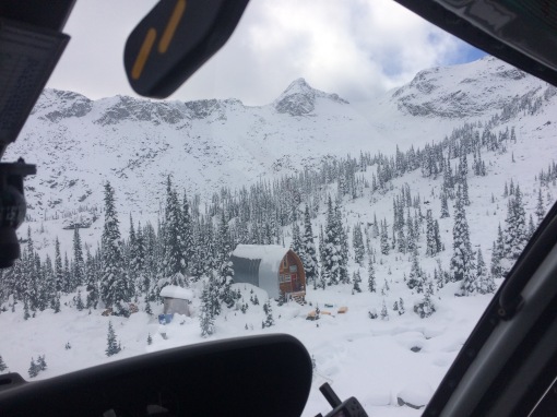
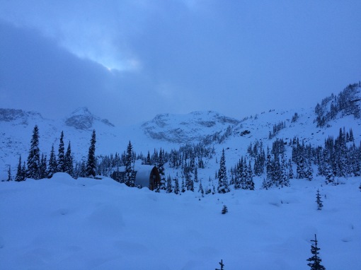
Nor do they maintain themselves, and beyond normal wear and tear from recreational users, the harsh mountain environment takes its toll on human structures as well. This summer and fall local ACC-Whistler members and other volunteers took on a major work project at the Wendy Thompson Hut, originally built by the club in 2000. Earlier this month I tagged along on one of their work parties to see exactly what was going on at the hut.

The day began with an early meeting for the group of volunteers at the Pemberton heliport, after which the first five workers were flown directly to the hut to prepare the site. Chief among these tasks was clearing pathways and digging out work sites in the already metre-deep (and now much deeper) snowpack. The rest of us drove to the staging point just off the Duffey Lake road and began preparing loads of firewood and building materials that would be shuttled to the hut by the helicopter.

IMG_4721

The staging area.

In total, seven loads were transported up to the hut. This all happened remarkably fast, thanks in large part to the heli pilot’s considerable skill and expertise. While this was going on, a third group of volunteers began the three-hour snowshoe trek from the staging area to the hut. Once the last load of materials arrived at the hut (and two loads of garbage, construction waste, and unneeded equipment was flown out), the last group of volunteers, myself included, was given a quick, scenic ride to the hut in the chopper.

IMG_4782

We unloaded with our gear and the heli set off. Work continued in a bustling but orderly manner, as there was an ambitious work plan for the afternoon. Some members had already begun framing a new room inside the hut, there was no shortage of firewood that needed to be moved and stacked, and I joined a group that began work on a new woodshed to keep the firewood dry and protected from the very deep coastal snowpack.

After a few frenzied hours, light began to fade, flurries started to fall, and small groups began to snowshoe back down the trail to our parked vehicles. But not before an impressive amount of work was accomplished, especially considering the deep snow and sub-zero temperatures.

IMG_4798

ACC-Whistler Chair Mitch Sulkers working on the new woodshed

It was a wonderful experience to tag along with such an enthusiastic and dedicated group of backcountry folk. Watching the crew at work underscored how much time and effort goes into maintaining our recreational infrastructure. If you find recreating in the backcountry rewarding, perhaps you should consider joining a local club and contributing your time as well (one need not be a member to join many of these work days).

The sum of the work completed this summer adds up to an impressive list of upgrades. The hut has been given a three-and-a-half metre (12-ft.) extension at the front of the building, complete with a new mudroom, a larger kitchen and an improved bunk area. A solar-powered lighting system was installed, and the old kerosene heater has been replaced with a wood-burning stove. A new wood shed was also built and stocked with three and a half chords of firewood, which should last the full winter if visitors use it wisely. Despite the increased space, capacity remains 16, making for a much more comfortable and functional space.

The new and improved Wendy Thompson Hut is now ready to go for the upcoming winter season. It is available only through reservation, which must be pre-arranged through the ACC-Whistler website. The hut fees go directly towards future maintenance and upgrades to the cabin, including building materials and the helicopter flights necessary to get them up into Marriot Basin. Local companies also help out donating time and materials.

While it is certainly an idyllic bit of mountain paradise, it must be noted that this hut is in a remote and wild setting, and all visitors should be self-sufficient, prepared for self-rescue, and equipped with all the necessary gear and knowledge to contend with hazards inherent to mountain and wilderness environments such as avalanches, extreme weather, and more.

IMG_4809

The Wendy Thompson Hut was named in honour of a long-time Whistler resident, ski patroller and paramedic who was tragically killed when a medical mercy flight she was working on crashed en route to Haida Gwaii in January 1995. She was an avid backcountry enthusiast, and the hut’s construction was funded by her family and estate to honour her memory and serve the outdoor community.

The hut was originally constructed in ACC-Whistler member Tom Dudley’s backyard. It was then de-assembled and transported to its alpine setting, with the project wrapping up that autumn before the first snow began to fall.

Built on the classic gothic arch design first developed by members of the British Columbia Mountaineering Club in the 1960s, this style is also exemplified by the local Wedgemount and Himmelsbach Huts among others. Local resident and master carpenter Werner Himmelsbach, for whom the hut at Russet Lake is named, even helped with the construction of the Wendy Thompson Hut 33 years after building his namesake shelter.

This summer’s renovation and upgrades are the result of two summers worth of planning and more than 400 volunteer days of actual work on-site, with approximately 40 different individuals contributing their time.

That’s a lot of gruelling, unpaid labour.

“The ACC-Whistler really enjoys projects that benefit the mountain and outdoor communities,” says Sulkers. “We have an amazing volunteer base.”

IMG_4811

Another major project they have spearheaded in recent years is the new Skywalk/Don MacLaurin Memorial hiking trail network on the east and north slopes of Rainbow Mountain.

The Whistler Museum has a soft spot for these simple, tough, and charming structures, and is currently researching and compiling a comprehensive history of the more than dozen Gothic Arch huts built throughout the Coast Mountains over the last 50 years. Those with stories to share about the construction of any of these huts, or simply visiting them, is encouraged to contact us at programs@whistlermuseum.org


Virtual Mountaineering?

21 10 2012

One of the great pleasures of mountaineering literature is its ability to transport the reader from their comfortable reading chair into a sublime alpine landscape. Conversely, anyone who has read a lot of mountaineering literature has dealt with the frustration of trying to follow the narrative through a complex, unfamiliar landscape.

For the last several weeks I’ve been chipping away at a  fun side project at work where I’ve been embedding our Neal Carter photographs into Google Earth and then re-creating a virtual tour of Carter & Townsend’s complete 1923 exploratory mountaineering expedition into the mountains immediately on the east side of the Whistler Valley.

The narration is drawn from Charles Townsend’s first-hand account of the trip, published in the British Columbia Mountaineering Club’s club journal, the B.C. Mountaineer. The BC climbing community at the time still had very close cultural ties to their largely British roots, and Townsend’s account is written very much in the characteristic “stiff upper lip” tradition. In the few instances where Townsend admits to danger or difficulty, you can be assured that things had turned nasty.

I’m struggling to come up with a clear, concise description of the finished product; “virtual mountaineering”? Digital historical re-enactment? Regardless, my aim was to re-package a mountaineering narrative in a manner that combines the amazing geo-spatial context of Google Earth, the aesthetic and documentary qualities of historical photographs, and the authenticity of a first-hand written account.

The first clip covers their first objective, the first ascent of Wedge Mountain, the highest peak in Garibaldi Park. Note that they did not use the current approach, but began instead from the Wedge Creek drainage, slightly to the south of Wedgemount Creek. Their only glimpse of Wedgemount Lake would have been from Wedge’s summit of ridge. I have down-climbed their climbing route up the south-west face and can attest that the “two-foot cubed” rocks make for extremely awkward travel; too large for “scree-surfing,” too small for the stability of larger boulders, but still large enough to do some serious damage.

The second clip follows the pair as they venture deeper into the Coast Mountain wilderness, completing the first ascent of the lower but equally formidable Mount James Turner.

The third and final clip covers the second half of their trip, for which they hiked up the predecessor of today’s Singing Pass trail and based out of the old prospector’s cabin near the Oboe-Cowboy  Ridge col. (I’m assuming BC Parks disassembled the cabin, probably in the forties or fifties. Does anyone know more about this?). This clip contains perhaps the most interesting scenery since they actually climb a pre-development Whistler Mountain, as well as the most challenging climbing during the first ascent of Mount Diavolo (named in honour of their “hellish” climbing experience).

This was a lot of fun, but also a lot of work. For those who are curious, the process was as follows:

  • Embed the photographs in Google Earth using the “Add photo” function. Familiarity with the landscape and patience with fidgety Google Earth controls comes in handy for getting things to line up just right.
  • Recording a rough of the tour using a video screen capture software (we used the very simple and awesomely named KRUT), using a combination of custom pathways, opacity controls,  and other Google Earth tricks. This process is far from perfect, and I’m interested to hear suggestions from anyone who has used Google Earth Pro, or knows how to customize Google Earth controls beyond the options provided in the program’s “preferences.”
  • Transcribe and record the audio.
  • Mix it all together using video editing software like Adobe Premiere. Substantial editing of the raw KRUT video file was necessary to eliminate the worst of Google Earth’s finickiness.

There’s plenty of potential for similar Google Earth-based historical narratives. Right now I’m looking forward to experimenting with on-screen annotation, integrate contemporary photography, and additional graphics. Such tours could potentially have a lot of different pedagogical applications as well.


Book Review: The Grizzly Manifesto by Jeff Gailus

4 01 2012

The Grizzly Manifesto: In Defence of the Great Bear
A Rocky Mountain Books Manifesto
by Jeff Gailus
168 pages, hardcover

A spectre is haunting North America’s grizzlies–the spectre of knuckleheads (as well as reckless industrialization, urban sprawl, highways, railroads, inert bureaucracies, and public apathy). Fortunately for grizzlies and their supporters, journalist and long-time wilderness advocate Jeff Gailus has written The Grizzly Manifesto (Rocky Mountain Books, $16.95 hardcover) to expose the crimes against grizzlies committed by this unholy alliance.

The Grizzly Manifesto is a welcome addition to Rocky Mountain Books’ timely “Manifesto Series” of concise, provocative hardcover essays about pressing environmental concerns. Where other authors might have adopted an orderly, systematic structure when confronted by the series’ confined format (maximum 25,000 words), Gailus has instead crafted a meandering essay that traces the authors’ own education in grizzly conservation interspersed with frequent insights about grizzly biology, politics, and popular culture.

A single chapter can wander from the grizzly’s diet (voracious and varied, but mostly plants), to their reproductive processes (slow, with some curious surprises), through their post-glacial migrations (often millennia ahead of humans), to their supreme roles in the spiritual lives of indigenous peoples across North America and Eurasia. This last bit even leads into a sustained consideration of the theory that the grizzly’s annual hibernation might have inspired the ancient human mythology of resurrection.

Such a literary scenic route contributes far more in terms of readability than it sacrifices in coherence. The effect is an enthralling narrative that navigates the intricacies of grizzly-conservation politics as purposefully as a well-worn game trail through a dark, overgrown forest, with hidden wonders sign-posted along the way.

The book confronts Canadians and their long-cherished wilderness values with the provocative challenge: like it or not, the fate of these archetypal wild beasts presents an unavoidable test-case as to whether or not we actually give a damn about preserving this nation’s natural heritage. Right now it doesn’t look good.

For many readers, Grizzly Manifesto will destroy the same illusions about Canada’s pre-eminence in all things environmental that Gailus has been forced to abandon through his decades-long efforts to improve Canadian conservation policies. While corrupt politicians, greedy industrialists, “knucklehead” recreationalists, and popular indifference all feel Gailus’ scorn, nobody comes away from The Grizzly Manifesto more abused than Parks Canada.

A firm believer in the Parks Branch’s primary responsibility to protect and preserve national park’s ecological integrity, Gailus scathingly details how the iconic institution is failing its sacred mandate. In perhaps his scathing climax, after outlining several severe and undeniable threats to Banff’s bruins, Gailus condemns the conservation objectives crafted by our park’s custodians with the damning assessment that “Parks Canada has set the bar so low that even a snake could slither over it.”

For any literary advocacy to be as moving as Gailus’ it must be aimed steadfastly at manifest injustice, but it must also be sustained by at least a modicum of genuine hope. In this regard Gailus’ efforts are nourished by the small, imperiled, but undeniable victory south of the border at Yellowstone National Park. Here, thanks to adaptive (and downright courageous) leadership and beefier environmental laws than our own, the region’s once-doomed grizzly population has tripled in recent decades. Canadians should take note.

In such a condensed form there are bound to be omissions, some glaring. While the imperiled fate of Alberta’s 700-odd grizzlies receives full treatment, only a few sentences go to the 25,000 that live in B.C. and the Territories. The word Alaska does not enter the text. Gailus does well to stick to his area of expertise, and the general terms of Banff’s grizzly battle may be largely universal, but a brief survey of other fronts would have made this book more immediately relevant to a larger audience.

Still, Gailus should be commended for crafting an argument on behalf of the great bear that is at once measured and passionate. The Grizzly Manifesto is an attractively packaged book that makes excellent work of the Manifestos‘ refreshing, punchy format. Anyone concerned about the continuing (accelerating!) loss of North America’s wild spaces and species will feel informed, disheartened, enraged, inspired, and, before Gailus is through, even a little empowered.


Neal Carter Climbing Album

8 11 2011

Among the tens of thousands of historical photos that the Whistler Museum holds in our archives, I think Neal Carters’ are my favourites. Carter was one of the most prolific mountaineers on the BC Coast during the 1920s and 1930s, gaining several first ascents. He also managed to turn his climbing hobby into a career, working as a surveyor first on hydro-survey crews around Garibaldi Lake, and then playing a major role in creating the first official topographic map of Garibaldi Park in 1928.

The mountains immediately surrounding Whistler were of special interest to him. Not only did he personally map much of the area (original copies of his massive topo map are in the Vancouver City and BC Provincial Archives), he was also instrumental in convincing the Provincial Government to expand Garibaldi Park in 1928 to approximately its current boundaries, including the Spearhead Range and the Wedge groups of peaks.

His first excursion into our local mountains occurred in September 1923 when he, along with fellow Vancouver climber Charles Townsend, spent two weeks bagging first ascents in the region. Beyond the sheer joy of two weeks climbing in such sublime terrain, the two were also on the lookout for potential sites for future BC Mountaineering Club summer camps, which had been held almost exclusively at Black Tusk Meadows for the last decade.

Their first night’s camp on the flanks of Wedge. Tent pole technology has come a long way in the last 88 years.

Using Rainbow Lodge as their base (they gave Myrtle Philip copies of their photos from this trip, which is how the museum ended up with them) they first scrambled up Wedge Creek with a week’s worth of provisions. Carter’s very matter-of-fact account printed in the BC Mountaineer belies their huge, gruelling days of bushwacking, navigating crevasse mazes, and scrambling up terribly steep and loose talus slopes in uncharted terrain.

The view south from Wedge to our familiar W-B backcountry: (l to r) Mounts Overlord, Pattison, Fissile, Trorey, Davidson, Castle Towers and Decker.

They managed to bag the first ascents of the twin giants of Wedge Mountain and Mount James Turner (whose summit was almost too small to build a cairn), while surveying and naming many of the surrounding peaks and glaciers, over seven days. Along the way they were treated to remarkably clear conditions, which, combined with Carter’s substantial technical skills as a photographer (crucial for accurate topographic surveys), produced some striking images of the surrounding landscape.

Getting radical near Mt. James Turner.

Returning back to Rainbow Lodge, they revelled in a massive dinner and comfortable night’s sleep in a bed, but were back at it early the next morning heading for the “largely unexplored” Spearhead Range. They first headed for Singing Pass-then known as “Avalanche Pass” and spent a night in the prospector’s cabin.

The rest of that week was spent climbing surrounding peaks such as Fissile (then Red Mountain), Overlord, and a further excursion for the first ascents of Mount Angelo and Mount Diavolo, which they named for their contrasting appearances.

Impressive solitude near Whistler’s peak.

This is just a small sample from more than fifty photos in our collection that Carter produced over the two-week dream trip. Most of them are beautiful in their own right, but are just as interesting as a unique perspective on a landscape that has become some of the most-visited “backcountry” terrain in the province. Scanning through the images, you get a sense of Carter’s excitement and wonder as he peered out over vast expanse of completely undeveloped, largely unknown terrain. I dare anyone who’s lost their stoke and has begun to take our amazing surroundings for granted to come browse Carter’s photo albums and not get inspired.


Deep Summer slideshow

1 08 2011

My new job at the Whistler Museum has given me the opportunity to work on a bunch of interesting projects. For one, I’ve been contributing weekly content to  the new site Whistler Is Awesome (part of a network of “_____ Is Awesome” sites).  This week’s post is the second half of a profile I wrote about pioneer local ski-mountaineer Pip Brock; a longer version with more photo content can be found on the Whistler Museum’s own blog, Whistorical.

Writing for WIAwesome led to the opportunity to produce a slideshow to be screened during the intermission of the Deep Summer Photo Challenge, one of the marquee events of Whistler’s annual Crankwork mountain bike festival. Deep Summer was, as always, an amazing show and I was really excited to have my work shown during the event (click here to see the top 3 shows from Deep Summer).

The Whistler Museum doesn’t have many mountain biking photographs in our archives (something we intend on rectifying in the future), so I decided to put a show together featuring a selection of the great summer mountaineering photos we have. This seemingly simple task  was more work than I expected, but I’m not going to complain about a few days of sitting at my desk listening to a great song and looking at beautiful old mountaineering photos.

Check it out:


Mining Whistler’s Past

9 07 2011

This is a re-post that I originally wrote for the Whistler Museum blog.

***

Whistler draws people from around the world for any number of reasons: skiing, biking, wildlife viewing, night clubs, fine dining, mining… wait, mining? Although a largely forgotten aspect of our region’s past, the (mostly unfulfilled) promise of underground riches was one of the Whistler Valley’s main draws in the days before “world-class shopping.”

Our local mining industry is actually 10,000 years old. Squamish archaeologist Rudy Reimer has found obsidian quarries in Garibaldi Park that were in use shortly after the retreat of continental ice sheets permitted the initial peopling of the region. Used for razor-sharp blades and fine jewellery, this volcanic glass can still be found among Garibaldi Park’s ancient lava flows.

Because each obsidian quarry has a distinct mineral composition, scientists are able to “fingerprint” fragments found at archaeological sites and trace them back to their source. Garibaldi obsidian, a valuable trade item, has been found throughout southern B.C. and Washington state.

The first non-indigenous visitors to Whistler–William Downie, a Scottish veteran of the California  gold rush (a “49er”), and Joseph Mackay, a former Hudson’s Bay Company employee (a fur trader, not a retail clerk)–were commissioned by the colonial government to explore the territory between Lillooet Lake (Pemberton) and Howe Sound (Squamish) in September 1858, hoping to find a better coastal access route to the booming gold mines of the B.C. interior. Dwindling rations forced Downie and Mackay to press on to to the coast before exploring the surrounding mountains.

Scouring our archival holdings is a little like exploratory mining. Our archivists recently uncovered a gem, this massive 1916 map of recorded mining claims in southwestern BC.

Following on their heels, tens of thousands of goldseekers rushed into B.C. during the 1860s. While the majority of them travelled along the Douglas Route up Lillooet Lake then northwards beyond Pemberton,  many other prospectors came up from Howe Sound and rooted around the surrounding creeks and mountains en route. Since mining men are notoriously secretive, however, very few records survive of prospecting activity prior to the twentieth century.

Among Whistler’s earliest known commercial mining operations was the Green Lake Mining and Milling Company, beginning operations at least as early as 1910. Run by Mr. A McEvoy of Vancouver, the Green Lake Co. worked 10 small claims at the 1000 – 1300 metre level on Whistler Mountain above Fitzsimmons creek. The workers lived  on the mountain’s lower slopes in cramped, drafty housing with a regrettable male-to-female ratio. Sound familiar? They found gold, silver, and copper, but never in commercially viable quantities.

Harry Horstman, a lanky prospector from Kansas, was to have greater staying power but similarly meagre returns. Despite his prairie roots, Horstman was at ease up high, living for decades in a log cabin near the 1600-metre level on Mount Sproatt. Digging several tunnels, Horstman found enough copper to eke out a modest living (supplemented by trapping), but he never struck a major load.

Harry Horstman at his Mount Sproatt cabin.

The Horstman Glacier on Blackcomb is named after this pioneering local. Horstman was a fixture in the Alta Lake community for decades, but still appreciated the seclusion of his mountain-top retreat. I wonder what he would think of the neon circus that goes on every summer on his namesake glacier!

Beginning in 1916, a group of twenty-odd men began operations as Alta Lake Mining near today’s Alpine Meadows neighbourhood. They excavated bog-iron ore, which occurs when iron dissolved in run-off water forms deposits in bogs or swamps. At their height of operations they sent 150 tons of bog iron a day down the PGE railway to Squamish, where it was then shipped to the Irondale smelter at Port Townsend, Washington.

Other locals also pursued small-scale prospecting and mining. Fitzsimmons Creek, which runs between Whistler and Blackcomb Mountains, is named after  Jimmy Fitzsimmons, who prospected throughout his namesake valley. Mining shafts that resulted from his exploration can still be found along the Singing Pass trail.

In the 1930s, locals Billie Bailiff (who also kept a trapline in the Singing Pass/Cheakamus Lake area) and Bill “Mac” MacDermott also dug mine shafts on the north side of Whistler Mountain, hoping to find the north end of the Britannia Mine’s massive copper vein. They didn’t succeed, but interest in Whistler Mountain’s underground remained.

Most of us know that the first ski lifts on Whistler Mountain started from Creekside. Fewer realize that the original plans included lifts and runs on Whistler’s north side, rising from near the present-day village. These plans had to be abandoned, however, because the provincial government chose to protect mineral claims on that side of the mountain now held by two companies, including the Canadian giant Noranda.

Unsurprisingly, mining claims didn’t interfere when plans to develop the north side of Whistler Mountain resurfaced in the late-1970s, as the provincial government was now a key investor in the planned resort expansion.

While never developing on a comparable scale to the Coast Mountain mega-mines at Brittania Beach or the Pioneer Mine, the quest for underground riches still played a formative role in Whistler’s early days. If one knows where to look, traces of this past mining activity can still be found throughout the local landscape. Local whitewater folk are familiar with the abandoned Ashlu gold mine because it is the drop-in point for a popular kayaking run.

Kayaker at the entrance to the abandoned Ashlu gold mine.

Though interesting to history buffs, this hidden legacy also poses significant physical and environmental hazards. For more on this context, track down the Summer 2011 issue of Kootenay Mountain Culture Magazine  for a short article on this titled “Rider Dun Gone.” (The article isn’t available on-line, but the magazine is free and can be found here.) For more info on industry and government efforts to track down and regulate Canada’s thousands of abandoned mines, check out the National Orphaned Abandoned Mines Initiative.

Want to learn more? Book an appointment to come mine our archives which contain old reports from the provincial Ministry of Mines, among other records. If you’re really keen you can even take your new knowledge into the woods and find some old mining ruins that haven’t yet been completely overtaken by the relentless coastal rainforest. But be careful! And remember, although relatively young these are archaeological sites; try to leave them undisturbed for others to enjoy.


Garibaldi Park: “Vancouver’s Alpine Playground”

13 05 2011

I’m deep in the final stages of thesis writing here, so I’ve got a bit of a “lazy” post this month.

Last weekend I attended the bi-annual BC Studies Conference in Kelowna. This year there was a good deal of environmental and recreational history- themed presentations, including papers on the fertile ground between these two fields about the Skagit Valley in BC’s Cascade Mountains by UBC’s Phil Van Huizen, the Bowron Lakes in the Northern Cariboo Mountains by my UNBC colleague Mica Jorgenson, the Forbidden Plateau on Vancouver Island by Dr. Jenny Clayton. As always, the informal discussions between sessions and at dinner/a pub were my favourite part of the conference.

Just as I was on my way out the door on the final day, I was happily informed that my paper on Garibaldi Park won the prize for best paper by an MA-level presenter. Below, I’ve included the opening passage of an earlier version of the paper (I think I like this intro better), in which I discuss efforts by Vancouver-based mountaineers to have a road constructed linking the city with the recently created Garibaldi Provincial Park.

Essentially, Garibaldi was envisioned as a grand mountain park akin to the “crown jewel” national parks like Banff and Jasper, except that Garibaldi’s proximity to an urban centre would make it accessible to people of more modest means. In effect, Garibaldi’s advocates hoped that the park’s development would integrate Garibaldi into the Greater Vancouver urban network, “democratizing” access to wilderness in the process.

Looking back upon a sojourn in the park, one is intensely aware of

a feeling that one has been living in an atmosphere differing peculiarly

from any afforded by other mountainous districts of British Columbia.

It is difficult to analyze this feeling, but it may possibly be because of

the close proximity of this beautiful wilderness to Vancouver, with its

teeming thousands. The contrast is so sharp. To be surrounded by the

din and roar of the big city in the morning, and the same evening to be

enveloped in the silence and grandeur of this vast mountainous region, 

tends towards the suggestion that one has  suddenly been transported

into different world.[i] 

Though undeniably wild and grand, in many ways Garibaldi Provincial Park is an urban park.

As suggested by prominent Victoria artist A.M.D. Fairbairn in the 1932 Victoria Daily Colonist article quoted above, the ability to enjoy the solitude of a remote mountain setting without enduring a lengthy voyage was more than a pleasant convenience; it was at the core of one’s encounter with the Garibaldi landscape.

The jarring experience of being rapidly transported between these two antithetical landscapes—like bolting between a sauna and a frigid winter lake—seemed both to enhance Garibaldi’s alpine grandeur, and, upon safe return, to underscore the exciting modernity of Vancouver.

A.M.D. Fairbairn, “Vacationing in Garibaldi National Park,” Victoria Daily Colonist, 30 October 1932, t, p3 (magazine section).

By 1932 Fairbairn could assume that such ideas would be well-received by British Columbia’s urban newspaper readership. A mere four decades earlier, however, most Lower Mainland residents would have considered the Garibaldi region as a marginal and mysterious wilderness.

An earlier Vancouver Province reporter noted that even the much-closer Grouse Mountain, a 1,200 meter peak that rises abruptly from Vancouver’s North Shore, “had a far away sound… such as is associated with Timbuctoo or the South Pole, and no one seemed to care to break in upon the virgin slumbers of the Sleeping Beauty.”[ii] In the 1890s, just as British Columbia’s Lower Mainland was rapidly urbanizing, Vancouver-based mountaineers began their first forays into the alpine wilderness.

While people had long ventured into British Columbia’s Coast Mountains, these mountaineers were peculiar because they did so simply for the sense of well-being they derived from experiencing these alpine landscapes first hand. No longer an ancient homeland, a place of work, a vast field of unexploited resources, or a regrettable, even “frightful” barrier to progress, the Coast Mountains were rediscovered as a still-wild, but now uplifting and “pure” natural environment.

Driven by the discovery of new mountain vistas, these climbers soon ventured beyond the rugged, but relatively small North Shore Mountains. 1904 witnessed the first attempt by coastal mountaineers to scale Mount Garibaldi (2,675m), the volcanic massif that dominates the Howe Sound skyline, seventy kilometres up coast from Vancouver. Three years later, a similarly composed party finally claimed victory over the Howe Sound giant.

These well-publicized expeditions drew attention to the region’s recreational potential while opening up a whole new field of alpine opportunity.

Beyond Garibaldi lay a vast, unmapped expanse of sprawling glaciers, volcanic landforms, picturesque meadows, and jewel-toned lakes. This territory soon became the preferred destination of coastal mountaineers.

Heavily flowered slopes above Garibaldi Lake. Photographer: John Davidson, ca. 1915. Courtesy City of Vancouver Archives.

Upon return, these same climbers began campaigning for the protection of the Garibaldi district through the development of a national or provincial park. Success was had in 1920 when the area surrounding Garibaldi Lake was set aside as the Garibaldi Provincial Reserve, and further in 1927 when the Garibaldi Park Act formally created the greatly expanded Garibaldi Provincial Park.[iv]

Through these activities Garibaldi came to be portrayed as “Vancouver’s Alpine Playground,” representing a new set of ideas which had obscured and displaced other narratives about the Garibaldi landscape. What began as the curious outlook of a handful of pioneer mountain-climbers became an increasingly normative way of thinking about the Coast Mountain landscape.

The widespread social benefits attributed to this wilderness park, Garibaldi’s champions argued, would play a crucial role in Vancouver’s future well-being and continued ascent as a world-class, modern metropolis. As such, the creation of Garibaldi Provincial Park was part of broader efforts to incorporate this region of the southern Coastal Mountains into Greater Vancouver as the city’s recreational hinterland.

Local newspapers were highly supportive of plans to develop Garibaldi Park. Using colourful illustrations and dramatized story-telling, dozens of stories recounted excursions to Garibaldi and portrayed the park as a favourable travel destination for Vancouverites, if only a road were built. Vancouver Province, 6 October 1929, 5 (magazine section).

Yet the campaign for park development put forth by Garibaldi’s champions was only partially fulfilled. Central to the “Alpine Playground” idea was the development of tourist accommodations and a motor-road from the heart of the park to make its recreational opportunities more accessible to residents of and visitors to Vancouver, any semblance of which would not come until the 1960s. Examining the failure to achieve this vision provides further insights into this crucial period of park formation in Canada.


[i] A.M.D. Fairbairn, “Vacationing in Garibaldi National Park” Victoria Daily Colonist, 1932 30 Oct. 1932, 3 (mag. sect.).

[ii] “Bring on New Peaks,” Vancouver Province, 16 April 1910, 20 (2nd sect.).

[iv]Report on Garibaldi Park and Contiguous Area, for the Honourable, Minister of Lands, B.C. (Victoria: B.C. Dept. of Lands, 1932), Frederick Charles Bell papers, British Columbia Provincial Archives (hereafter BCA), MS-1095..


Not So Humble Roots

11 04 2011

Growing up on a farm south of Winnipeg, I dreamt of British Columbia.

Totem poles and snow-capped mountains symbolized the west coast

province. I fell in love sight unseen with the west beyond the west.

In these opening lines of her best-selling history of British Columbia, The West Beyond the West, Jean Barman, nicely summed up the romantic sentiment that has inspired so many Canadians to “Go West!”

Boasting the mighty Gatineau Hills, the Outaouais region of west Quebec where I grew up was only marginally more mountain-like than Barman’s Manitoba farm. By the time I was in junior high, still a few years away from even seeing a mountain firsthand, I already knew that I would one day call “The West” home.

Overlooking the Ottawa Valley from the Gatineau Hills in winter. bradleyslackphotography.ca

The dominant orientation of nearly four centuries of North American history has been westward. While the lure of cheap land and abundant resources (enabled by the tragic effects of colonial encounter) propelled the continent’s initial resettlement, in later years, the call of the mountains helped sustain this westward migration.

North America’s first mountaineers (in the modern, European sense) came from eastern Canada and New England along newly-built railroads, seeking adventure in the famed Canadian Rockies. Even the Alpine Club of Canada was founded in Winnipeg of all places. Surely, every western Canadian town has strong eastern ties, dating back centuries and continuing up to the present. It is a recurring joke here in Whistler to wonder out loud if there are any people left in Ontario (or Australia, for that matter), for they all seem to have moved here.

Many of my friends here in Whistler went to the same high school as me, and I have childhood friends spread throughout western mountain towns. Recently, I uncovered two much older links between my childhood home and the Mountain West.

"Mouth of the Homathko River" by Frederick Whymper, 1864. The painting depicts the terminus of Waddingtons Road, also known as Waddington Harbour, where the Homathko flows into Bute Inlet. Source: British Columbia Archives.

I’ve been studying Alfred Waddington for a few years now. The British-born, Victoria-based entrepreneur was the brains, money, and enthusiasm behind an audacious plan to build a wagon road from British Columbia’s Bute Inlet to the booming Cariboo goldfields in the early 1860s. Despite having to pass through the incredibly rugged central Coast Mountains, by April 1864 the project was progressing well and the work crew optimistically hoped to complete the road that summer.

But it was not meant to be. Following a dispute over pay and maltreatment, a party of local Tsilhqot’in men attacked and killed fourteen of Waddington’s work crew. In response the colonial authorities organized a massive manhunt through the central British Columbia wilderness which ended with the hanging of six Tsilhqot’in men. This series of events, now known as the Chilcotin War, was one of the most tramautic and controversial episodes in British Columbia history.

(Great Unsolved Mysteries in Canadian History, an innovative tool for teaching high-school-level Canadian History, has a great account of the Chilcotin War here. Chapters 2 and 3 from Frederick Whymper’s 1868 Travel and Adventure in Alaska, provide a fascinating contemporary account of Waddington’s road project, the Coast Mountain landscape, and the Chilcotin War. Older brother of the famed alpinist Edward Whymper, Frederick visited Bute Inlet in 1864, en route to Alaska, leaving  just weeks before the Chilcotin War.)

The Chilcotin War put an immediate halt to Waddington’s road-building enterprise, and although his route was nearly selected as the final leg of the first trans-Canada railway, only a handful of people of European descent visited the region over the next half century. The central Coast Mountains became deepest, darkest British Columbia.

When Don and Phyllis Munday “discovered” a massive peak somewhere in the middle of this foreboding wilderness in 1925, they called it, appropriately, “Mystery Mountain.” And while this title remained widely used for decades, the provincial government preferred to honour the valiant, if unsuccessful, exploits of one of the province’s most energetic pioneers by officially naming British Columbia’s highest peak “Mount Waddington.”

The remains of Waddingtons trail through the Homathko Canyon. Photograph taken by Charles Horetzky, a member of the 1872 Canadian Pacific Railway exploratory survey, led by Sir Sandforn Fleming. Source: British Columbia Archives.

I’ve been fascinated by this story for some time, but only while reading an out-of-print biography of Waddington a few months ago did I learn of the man’s final years. Waddington spent much time in Ottawa promoting his national railway scheme, and it was here, in February 1872, that he succumbed to smallpox. As was common for prominent Ottawans at the time, he was buried at St. James Cemetery, across the Ottawa River in Hull, Quebec.

I have passed by this cemetery hundreds, if not thousands, of times, though I have never been in. It lies on the main route between my childhood home and downtown Ottawa, and is only a few hundred metres from my junior high. Little did I know that in that unassuming field lay such a close connection to the great peak whose jagged summit astounded even Sir Edmund Hilary when he, accompanied by Phyllis Munday, toured Mt. Waddington in a helicopter in 1955.

Alfred Waddingtons gravestone, St. James cemetary, Hull, Quebec. It reads: ALFRED WADDINGTON the original promoter of the CANADA PACIFIC RAILWAY. Born at Crescent House, Brampton, London, Oct. 2nd, 1801. Died at Ottawa, Feb. 26th, 1872.

At he time of Waddington’s burial, just a few kilometres down the road (in Aylmer, my hometown), lived a teenager named James McArthur, Perhaps he was prone to dreaming of mountains, sight unseen, as well. for within a few years McArthur made the move out west to work for the Dominion Land Survey.

"The Field Hotel below Mount Stephen, British Columbia" by Edward Roper. Painted in the same year as J.J. McArthurs historic ascent of the same mountain. Courtesy collectionscanada.gc.ca.

In September 1887 while mapping terrain adjacent to the recently completed CPR, the same railway that Waddington promoted but never lived to see, McArthur climbed to the summit of Mount Stephen which looms above the village of Field, British Columbia just west of the Continental Divide. This was the first non-indigenous ascent of a Canadian peak above 10,000 feet, leading Chic Scott, in his excellent history of Canadian mountaineering Pushing the Limits, to proclaim McArthur “the first Canadian mountaineer.”

McArthur would have a long, successful survey career, first in the Rockies, and later in the St. Elias Mountains, eventually being appointed Canadian Commissioner of the 1917 survey to locate the boundary between Alaska and Yukon Territory.

When I was fifteen, on my first visit to the Canadian Rockies, I can recall being surprised to read the name “Mount Aylmer” written above a massive pyramid-shaped mountain on one of those interpretive panoramic photos which one finds at roadside lookouts in our national parks. I figured the name was just a funny coincidence with as little to do with my home town as the canned tomatoes.

In fact, the peak was another of McArthur’s many first ascents, and he felt it appropriate to commemorate his eastern roots by attaching the name of the west-Quebec logging town to the highest peak near Banff.

Many historians and public figures have celebrated Canada’s western mountains (often, incorrectly, referred to collectively as the Rocky Mountains) as symbols of national identity. Certainly, the allure of our mountain landscapes resonate far beyond their immediate neighbourhood, and it is perhaps worth pondering how many life trajectories have been shaped by these unyielding peaks.


Retro Natural History Artwork

25 03 2011

As a child I spent countless hours browsing through the world atlas and set of natural history encyclopedias that sat on my mother’s cluttered bookshelf. Nowadays websites like Wikipedia do an admirable job satisfying (and fuelling) this sort of wandering curiousity, and Google Earth is a pretty amazing update on the old-fashioned globe, but computer screens lack the pleasure of gliding your finger along the glossy coastline of Patagonia or a tiger’s gleaming tooth. (Then again, I don’t have an iPad. Yet.)

So I was thrilled when, a few years back, I came across a full set of the Illustrated Natural History of Canada at a garage sale here in Whistler. Unfortunately I was biking home fully-loaded with groceries, so I could only carry home two of the series’ nine volumes. The series was organized according to our nation’s broad environmental zones, so naturally, I chose “The Pacific Coast” and “The Mountain Barrier.”

What a find. I definitely need to track down the rest of the volumes through an on-line used book store.

"Eocene Life Fleeing a Volcano." Growing up, dinosaurs were probably my most serious mania. I really enjoy the thought that this exact scene, depicting the wave of volcanic activity that formed the Coast Mountains a few dozen million years ago, occurred just up the street from where I live today.

Beyond the inherent interest of the subject matter, I really enjoy browsing older environmental literature and educational materials for the window they offer into changing popular environmental attitudes. Published in 1970 by Natural Science of Canada, the series offers a cool expression of the growing concern for environmental degradation that followed such landmark events as Rachel Carson’s Silent Spring (1962) and which was reflected by major shifts in North American environmental policy.

The Illustrated Natural History of Canada, the publisher claimed, was “devoted to explaining and illustrating the entire natural formation and development of our country…. ” Beyond this popular science component, the series was clearly inspired by a desire to instill in the Canadian populace an appreciation of our nation’s natural wonders, and a concern for their imperiled state. Each volume concludes with a chapter outlining major conservation concerns in its respective region, offering as a scathing condemnation of the era’s over-zealous “development-at-all-costs” economic policies.

The science and advocacy are well-written, if a little dry, but the series’ major success lies in its wonderful use of images to fully express the drama and wonder of our natural landscapes. The publisher even went so far as to claim on the dustjacket that the series was an “important and unique event in Canadian publishing history” which constituted a “landmark in the visual portrayal of the full range and splendour of our natural history.”

I often find myself leisurely browsing through my two volumes, no less entranced than I was by Wings, Paws, Hooves, and Flippers two decades earlier, so I figured I’d scan a few of my favourite images and post them here.

"Nootka Whale Hunting"

"Mountains in the Making"

"Many Mountain Shapes"

"The Mountain-bound Indians." A completely accurate portrayal of day-to-day life of the region's indigenous peoples.


Whistler & Region Repeat Photography Project

29 12 2010

If a picture is worth a thousand words, then a lot can be said about as picturesque a place as Whistler. Thanks to the efforts of a century’s worth of residents and visitors, a rich photographic heritage exists documenting the landscape surrounding what is today Whistler, British Columbia. While pioneers such as the Alex & Myrtle Phillip recorded the nascent settlement of Alta Lake, mountaineers such as Neal Carter and Don & Phyllis Munday captured images of climbers at play amidst panoramic alpine vistas. Since the start of ski resort development in the 1950s, the photographic record has grown exponentially.

Landscape is, arguably, Whistler’s defining feature. As any number of marketing campaigns plainly demonstrate, lifestyle-oriented residents and adventure-seeking tourists from around the world are drawn to Whistler by the beauty of the region’s natural environment. Natural it may be, but millennia of human activity, intensified over the last fifty years, have left their mark on our cherished landscape, for better and for worse.

Hunter and dog in the Fitzsimmons Range near Whistler Mountain, 1920s. Overlord Mountain and Glacier in background. Courtesy Whistler Museum and Archives Society.

Both local and global processes have effected our regional ecology. A First Nations trail followed by early prospectors and settlers became a dirt road navigated by keen post-war skiers, and is now the four lane Sea-to-Sky Highways linking Whistler to Vancouver and the world. A town of 12,000 (give or take, plus over 40,000 hotel beds) emerged seemingly overnight. Ski runs, chairlifts and gondolas crisscross (and even span between) two mountainsides.

Franz Wilhelmson pointing out the ski area that he helped develop. Early 1960s. Courtesy Whistler Museum and Archives Society.

Many strong visions for the development (and prevention thereof) of our surroundings have been put forth. Rarely have they gone uncontested. Recent examples include the Peak-to-Peak gondola; disparaged by many local residents as an expensive eyesore, it is an undeniably cool, if somewhat useless, ride. Meanwhile, the ongoing debate over logging in the valley demonstrates widespread misunderstanding divergent opinions of resource industries in our valley, past and present. In addition to these various human factors are many inherently capricious environmental processes–from wetland ecology to climate change. Clearly, our region’s current landscape is the result of a complex array of disparate factors.

Inspired by the Mountain Legacy Project and other initiatives, I figured that “repeat photography” would be an excellent way to simultaneously celebrate the Coast Mountains’ beautiful landscape and examine the drastic changes that our region has undergone over the years.

Essentially, I hoped to take old  photographs like the one above, and “re-photograph” the same location to show how the landscape and the people within it have changed in the intervening years. This pairing of past and present photographs will add temporal depth to the images, augmenting our capacity to evaluate landscape change over time. While historic-contemporary image pairings will be the focus of the project,  other archival materials such as climber’s journals, survey reports, and maps will also be examined to provide context for the photographs.

I recently received the good news that my proposal for just such a project, to be developed in partnership with the Whistler Museum, will receive support from the Network in Canadian History & Environment (NiCHE). Click here for the full list of projects NiCHE will be supporting this year .

For some rough examples of what a repeat photography exhibit would entail, take the following image pairs. These two  trail maps (not photographs, but demonstrative images nonetheless) illustrate the extent of  the ongoing development of runs, lifts and other infrastructure on Whistler and, later, Blackcomb Mountains, now North America’s largest ski resort.

A trail map of the Whistler Mountain from 1966.

Deforestation, erosion, and pollution have ensued, but the ski area’s ecological impacts are not as overwhelmingly negative as one might assume. For one, Whistler-Blackcomb has made efforts to ensure that cut ski runs remain viable wildlife habitat. Such clearings can often provide more food (shoots, berries, etc.) for large game animals than mature forest. This fact that was well understood by many indigenous societies which regularly burned wooded areas to support large game populations. Whistler and Blackcomb Mountains continue to support large wildlife populations, including the several dozen black bears that are a common sight in summer.

A current Whistler-Blackcomb trailmap.

These next two images, portraying Garibaldi Lake and Mount Garibaldi from the aptly named Panorama Ridge, span almost eight decades. In this case the photographic record clearly documents the effects of climate change–the  massive recession of the glaciers on the north slope of Mount Garibaldi–on a landscape that is widely recognized as “pristine” wilderness.

Mountaineers on Panorama Ridge take in the view of Garibaldi Lake, from a 1943 Vancouver Province article.

A contemporary image of the same vista, minus the hikers. Courtesy Wikimedia Commons.

.

Although I hope that the image pairings will provide insight into ecological change, the project is not intended to produce results of a scientific rigour. Still, the precision of repeat photography makes the medium an effective means of informing dialogue about a variety of environmental issues.

Additionally, the aesthetic qualities of the Whistler landscape as well as the human presence in the photographs will present the opportunity to explore the cultural aspects of the human-nature relationship.

I have found several near-identical images, for example, of Garibaldi Lake like the two shown here. Drawn from a variety of newspaper articles, government reports, and tourism brochures from the inter-war period, these vistas of a serene lake amidst sublime glacial peaks were used to portray Garibaldi Park’s “diversified charms,” a recurring catchphrase in promotional literature for the park at the time.

If I choose to rephotograph the Vancouver Province image, or other pictures that include human subjects, I will also have the pleasure to get my friends involved as contemporary figures to contrast with those in the historical images, their fashions, activities, and attitudes. It is this potential to explore cultural and natural history at the same time that excites me most about this project.


Spearhead Huts

1 12 2010

Like most backcountry skiers, nights spent in ski huts are among my most cherished mountain memories.

Sleeping in a snow cave might put hair on your chest, but after a long day in the mountains, the basic comforts provided by a mountain hut can seem like the Ritz-Carleton penthouse.

Uniquely social places in the midst of barren alpine wilderness, a hut’s forced proximity and the shared excitement of a day’s skiing melts away the awkward social interactions of “down there,” making kindred spirits out of complete strangers.

And when things go awry, the safety net provided by mountain refuges can make all the difference.

Refuge Albert Premier, Le Tour Glacier, France. Photo: bradleyslackphotography.ca 

The other night I went to a fundraiser for the Spearhead Huts committee.  The initiative began as a memorial for a couple of avid backcountry skiers who tragically passed away while skiing a few years ago. Essentially, the plan is to build 3 or 4 backcountry huts throughout the Spearhead Traverse, the 40-kilometre long horseshoe of high alpine terrain that links Whistler and Blackcomb Mountains.

There are already several backcountry huts scattered throughout the Coast Mountains, including the Himmelsbach hut near the Whistler end of the Spearhead Traverse. This new project, however, would create the region’s first multi-day hut-to-hut traverse like those which exist in the Rockies and the Alps; the Haute Route between Chamonix, France and Zermatt, Switzerland being the most renowned.

Hut-based traverses are a wonderfully “civilized” way of experiencing truly dramatic and remote landscapes, enabling skiers (and summer-time hikers) to cover large swaths of terrain without the added strain of carrying camping gear and 24-hour-a-day exposure to the elements.  Dry clothes on day 3 are the height of luxury.

While the traverse has been completed twice in a single day in a pretty astonishing feat of endurance, those more intent on taking in the scenery, or actually skiing, generally cover the route over two to four days.

Some may complain that the construction of additional huts will increase traffic, and diminish the sort of “out there” wilderness experience that many backcountry enthusiasts seek, but really, what better location is there for the huts?The area is already some of the most heavily used backcountry terrain in the province, and the combination of relatively mellow glaciers surrounded by dramatic peaks is perfectly suited for hut-based touring.

The environmental impact of the project mught even end up as a positive, as there are currently no overnight camping facilities aside from the Himmelsbach hut outhouse, and the huts would concentrate campers into three or four specific sites. 

A 1934 Vancouver Province article following the first successful ski traverse of the Waddington Range. The adventurer's returned to Vancouver raving about B.C. as a "skier's paradise," advocating the creation of a system of backcountry ski huts to improve access to and recreational opportunities in the Coast Mountain wilderness.

At the fundraiser the other night the BCMC reps had a large map of the Spearhead on display which showed  potential hut sites. I can’t find this online yet, but when I do, I’ll post a link. So far, the region has been divided into 4 zones, with 3 or 4 huts to be built throughout the zones.

I, for one, hope they keep the Himmelsbach hut, or even upgrade  the spartan refuge with some insulation and a basic woodstove. It’s in a perfect location beside Russett Lake and at the base of Fissile Mountain’s amazing Northwest Face ski runs.

Also, in zone 1 (from the Blackcomb backcountry to Mount Pattison), the three potential sites are Decker flats, the east side of Decker Mountain, and the Trorey-Pattison col. I was told that the first option is being considered because it is more accessible for summer hikers, but really hope they opt for one of the latter sites.

Decker flats can easily be reached in an hour from Blackcomb’s ski lifts, and putting a backcountry hut this close to the ski area would further blur the distinction between in-bounds and out-of-bounds terrain that is already largely ignored in the area. The last thing we need is more unprepared people heading out into this unpatrolled, avalanche-prone terrain because they heard there’s a hut back there.

Also, I spent a night in a snow cave at the Trorey-Pattison col a few winters back and it’s a pretty spectacular spot,with full peak-to valley views of Wedge Mountain on one side, and Fissile mountain on the other. If they built a hut there, I’d want to move in full-time.

What excites me most about the project is how much more accessible it will make the prize descents of the range. Classic steep descents such as the north faces of Fitzsimmons, Iago, and Tremor, used to entail either a big approach, a big pack, or both. When the huts go in, you’ll be able to ski them and countless others with a day pack and only a modest approach. Awesome.

For more info, visit these sites:

http://www.spearheadhuts.org/ http://www.keesandclaire.com/

I just found this on-line reader for Mountain Life Magazine. Check it out to see the images and page layout for my “Ancient Alpinists” article (page 88-89), and make sure to browse the rest of the mag’s excellent content as well.


A Couple of Magazines Worth Checking Out…

24 11 2010

Ski season is here! To celebrate opening day here in Whistler, I’ve got some more big mountain ski content for you.

If you were interested by my recent post about the confluence of freeriding, extreme skiing, and ski-mountaineering, then there is plenty of stuff to check out in the latest round of ski and snowboard magazines.

First, the cover story for the latest issue of Powder, “Return of the Extreme Skier,” profiles some American and Swedish veterans of the Chamonix steep skiing scene. Showcasing the sort of progression I touched upon last month, these guys have been charging down classic ski-mountaineering routes on fat skis and in mid-winter conditions.

Also in the mag there is a short piece about Jeremy Jones which attempts to finally break down the barrier between skiers and snowboarders that really became irrelevant a decade ago. You may have noticed that I didn’t distinguish between the two sports in my own article, and it was deliberate. I almost always ride in mixed groups. Split-boards have leveled the playing field enough that, in most situations, the capabilities of the two types of gear are “different but equal.”

Finally, there is a short write-up about Whistler-based ski-mountaineer J.D. Hare’s recent first descents in the Tantalus Range. The latest issue of  Mountain Life Magazine has a first-hand account of the same trip. Here’s a video of the “mellower” of the two lines he performed in a single, epic day last winter.

Elsewhere, Snowboard Canada‘s current “Tech Issue” has a pretty rad feature about a crew of snowboard-mountaineers who are using Google Earth to identify and locate new snowmobile-accessed riding zones in the mountains to the north of their Pemberton, BC homes. Aside from some burly riding (and a couple of my brother’s photos), the article provides some compelling insight into territorial exploration in today’s world. While purists and armchair explorers might claim that the use of  technology (including snowmobiles) lessens their discoveries, I doubt these guys care. They’re getting after it and reaping the rewards.

Also in the same issue is a counterpart article about urban snowboarders using Google Streetview to locate new jibs (skateboard-style urban features), and a detailed article which traces the progression of freestyle snowboarding over the last twenty years, “from tindys to triple-corks.”

None of these articles are available online, so I’ll throw this in for some more web-based content: an article about Yuichiro Miura’s attempt to ski from the South Col of Mount Everest in 1970.  Here’s a short clip to accompany the article, but to fully appreciate this expedition in all it’s bizarre glory, track down a copy of The Man Who Skied Down Everest.

Many of the ski descents Miura attempted in the 60s and 70s would have been groundbreaking on their own, but, marching to his own beat, he decided to schuss (ski without turning) and use a parachute to slow him down for good measure. In a sport renowned for its eccentrics and free-thinkers, Miura has to go down as one of skiing’s squarest pegs.

Hopefully this round of articles gives some insights into the current state of the ski/snowboard world, and gets all the riders out there stoked for the snow. If you’re going out into the mountains, please play safe.


Ancient Alpinists: First Nations in the Coast Mountain Past

6 11 2010

This article was published in the latest issue of Mountain Life Magazine (Fall/Winter 2010). Pick up a free copy if you are in the Vancouver/Sea-to-Sky region, or view it online here (page 88-89).

Sure, old-growth forests are nice and the ocean’s pretty cool, but the alpine is where it’s at. There’s nothing like standing amidst jagged peaks, sprawling glaciers, and kaleidoscope meadows on a bluebird day. Or, for that matter, not seeing anything at all in a vertigo-inducing whiteout.

It’s no secret that the Coast Mountain alpine offers some of the most mind-blowing opportunities for adventure on Earth. Conversations about “pioneers” in these inspiring, challenging landscapes usually begin with the founders of Whistler Mountain, or, less often, early mountaineers like Don and Phyllis Munday.

But long before these mountain heroes, coastal First Nations people were venturing above tree-line. While local First Nations history has received greater attention of late, these stories are usually set at lower elevations. This alpine amnesia is surprising, considering that anthropologists have long emphasized how the coast’s populous and sophisticated societies developed through full, expert use of our region’s natural riches.

Historically, First Nations people saw the Coast Mountain alpine much like Sea-to-Sky residents today, as a powerful landscape with plenty to offer. Bridging this ancient fascination into the present is SFU archaeologist Dr. Rudy Reimer, a Squamish Nation member at the forefront of alpine archaeology. Think Indiana Jones with an ice axe. Reimer combines his own field research with oral histories to write First Peoples back into the social memory of the Coast Mountain landscape.

And a deep memory it is. Reimer has identified sites in Garibaldi Park up to 10,000 years old.  “Other locations,” he explains, “were off limits due to their associations with powerful mythical beings such as the Thunderbird, whose perch is atop what is known to some as Black Tusk.”

Drawing materials from their immediate surroundings, they developed gear resembling modern alpenstocks, snowshoes, crampons and climbing ropes for travel into the alpine. And they probably had a lot of fun while up there.

The berry patches that thrive in most well-lit areas saw some of the heaviest use. Since fruit ripen slower at altitude, harvesters climbed progressively up-slope, finding fresh berries well into the fall. Of course, berry patches attract other visitors like elk, deer, and bear which were  hunted throughout the sub-alpine parkland.

The most sought-after prey were mountain goats, whose meat and wool blankets served as markers of status. The goats’ meat was fattest and their fur thickest in late fall so hunters often grappled with early snowfalls that left alpine rock extra slick, and crevasses thinly covered. Drawing materials from their immediate surroundings, they developed gear resembling modern alpenstocks, snowshoes, crampons and climbing ropes to better navigate the terrain.

Some of the best hunting zones lay among the gnarly crags of the Tantalus Range, named Twi’liks in Squamish after a legendary hunter. The dangers of the hunt demanded years of practice and apprenticeship, but also added prestige to the kill. Imagine headstrong Squamish youths aspiring to chase these woolly beasts, much like today’s groms dream of steep, exposed ski lines.

Vancouver’s Dr. Duncan Bell-Irving witnessed this prowess firsthand on an 1889 North Shore hunting trip guided by Squamish Chief Joe Capilano. One evening while camped beneath the West Lion, Chief Capilano asked the doctor to time one of his men climb the iconic peak. As Irving recounted, “the lithe youth stripped naked then went up the rocky face like a cat, springing from ledge to ledge, all the time in plain view of the watchers below. Reaching the summit he turned, waved his arms, and then commenced a descent so swift as to seem almost incredible.”

Next time you climb the West Lion try to beat one Squamish youth’s time of twenty minutes (return), clothing optional.

Another alpine lure was forged during the Coast Range’s fiery past. Obsidian is used for razor-sharp blades and fine jewellery around the world, and  this volcanic glass can still be found among Garibaldi Park’s ancient lava flows. Further north, Mount Edziza was B.C.’s largest producer, with other sources in the Chilcotin’s Rainbow Range and, possibly, near the glacial dome of Mount Silverthrone, BC’s highest volcano.

Because each obsidian quarry has a distinct composition, scientists are able to “fingerprint” fragments found at archaeological sites and trace them back to their source. Garibaldi obsidian has been found throughout southern B.C. and Washington state, while Edziza filled orders as far away as Alaska and Alberta.

Obsidian was just one of many commodities exchanged across a broad trade network. The “iceman” found melting from a glacier in the St. Elias Range in 1999 likely perished following one of these routes, roughly 500 years ago.

More recently, an 1868 map of B.C.’s central coast recorded two “Indian Trails.” Surveying river valleys for possible railway routes, the mapmakers knew next to nothing about the terrain these trails crossed. Both routes would have traversed massive glacial plateaus– just west of Mount Waddington along the Franklin Glacier, and the Lillooet Icefield, respectively. Nowadays, few venture into these arctic landscapes without years of mountaineering experience.

Two “Indian Trails” were recorded on this 1868 map. One track crossed between the Homathko and Klinaklini valleys, while the other connected the Southgate drainage to the Bridge River country near Bralorne.

Through his work Reimer hopes to challenge long-held perceptions of these cherished places:I hope that my research will show that mountainous areas have a long First Nations presence. My elders have always told me that our ancestors used the entirety of our territory, from the tops of the mountains to the depths of the sea. The fact that he is uncovering his own people’s heritage makes his work among the peaks especially rewarding.

And he’s definitely having a lot of fun up there.


Deeper: The Globalization of “Extreme”

21 10 2010

Autumn is a funny time of year in ski country. Anticipation for the upcoming winter builds into a palpable nervous energy, waiting to be released when opening day finally comes. Here on the wet coast, miserable fall weather adds to this anxiety, though this year the cruel irony of unusually clear skies is making ski bums nervous about the  coming winter’s snowpack. A snow-lover’s catch 22.

Unlike the weather, you can rely on the yearly onslaught of ski and snowboard movie premieres that hits ski towns every autumn, drumming up a frenzy (conveniently enough for the films’ sponsors, just in time for the flashy new gear showcased in the films to hit storefronts). Over the last few months Whistler has seen several new films, all selling out multiple screenings, but the most heavily anticipated is yet to come.

In two days I will attend the Whistler premiere of Deeper, the brainchild of Jeremy Jones, hands-down the world’s top big mountain snowboarder, along with a slew of fellow mountain slayers.

Video 1: Trailer for Deeper

Aside from the top-notch talent, what sets Deeper apart is the story it conveys. In a dramatic departure from other mainstream ski movies (including Jones’ previous film segments), all of the action in Deeper was accessed without the aid of helicopters or  snowmobiles (check out this “behind the scenes” article).

This low-carbon approach reflects Jones’ environmental beliefs (in 2007 Jones founded the climate change advocacy foundation “Protect Out Winters“), but the idea for a fully self-propelled snowboard movie also draws from an evolution in Jones’ approach to snowboarding, inspired by the sports’ international roots.

In this latter respect, Deeper is a microcosm for recent developments within the global skiing/snowboarding community: a convergence between two distinct big-mountain cultures that has become a driving force behind the sport’s’ continued progression.

A new era in skiing was born in 1967 when Swiss mountaineer Sylvain Saudan completed the first ski descent of the Spencer Couloir above Chamonix, France, earning him the nickname “Skieur de l’Impossible.” Soon more ski-mountaineers like  Patrick Vallencant, Jean-Marc Boivin, and Anselme Baud were tackling increasingly steep, technically challenging mountain faces and the sport of extreme skiing was born.

Death, for these extremists, was a fact of life. On most of these lines falling was not an option, so the skiing, like climbing, was slow, methodical, precise. The mountaineers’ skills and ethic of self-reliance continued to be revered.

Video 2: First descent of the Arête de Peuterey, on Mont Blanc, France by Patrick Vallençant and Anselme Baud in 1977.

A few North Americans ski mountaineers such as Bill Briggs would perform similar feats, but this brand of extreme skiing never became as popular, nor drew as much media coverage, as it did across the pond. In the 1980s, skiers such as Doug Coombs, Trevor Peterson, and Eric Pehota–all ski-mountaineers at heart–began experimenting with a new approach to the mountains they loved.

The iconic 1971 photograph of Bill Briggs ski tracks on the summit of Wyoming's Grand Teton, captured from a plane a few days after Briggs' un-filmed descent to quell disbelief.

At that time the American ski industry was in a period of growth, increasingly propelled by athlete-driven marketing based on action photography and filmmaking. Flush with corporate cash, film crews increasingly used helicopters to film in remote and dramatic mountain settings away from traditional ski areas.

With its unique combination of the imposing Chugach Mountains’, extraordinarily stable coastal snowpack, and overwhelming aura of wilderness, Valdez, Alaska became the mecca of North American extreme skiing, just as Chamonix, with its endless couloirs and deep mountaineering lore, was Europe’s.

Meanwhile, helicopters freed the athletes from many of the constraints of the mountaineering approach: fatigue, prolonged exposure to avalanches, heavy packs, and specialized ski gear that had to perform as well on the way up as it did coming down.

Ski-mountaineering traditionalists, meanwhile,  contended (and still contend) that helicopter-assisted skiing was a hollow victory. Such technological shortcuts severed the visceral connection between man and mountain which was essential to the ski-mountaineering experience.

While the ski-mountaineering purists progressed towards increasingly steep, hazardous, complex routes, freeskiers (as they came to be known) descended slightly less technical lines–coated in powder snow, preferably–but with far greater speed and fluidity. The greater influence of snowboarding in North America is evident, especially once aspects of freestyle riding developed in terrain parks began to be applied to natural terrain.

Which of these ski styles was most impressive is debatable, but freeskiing was definitely better-suited to film:

Video 3: The groundbreaking segment by Johann Olofsson (my favourite snowboarder growing up) in the 1996 snowboard film TB5. Filmed primarily in California’s Sierras and Alaska’s Chugach Range.

Video 4: The cutting edge of freesking: Eric Hjorleifson’s segment in Seven Sunny Days (2008). Most of the filming was done with helicopters or snowmobiles, but shots where he’s wearing a backpack were accessed on foot (they even show a few short clips of him ski-touring).

Throughout the 1990s and early 2000s these two extreme skiing sub-cultures progressed in parallel but remained relatively isolated (with notable exceptions). In recent years, however, growing concern for climate change, massive improvements in backcountry ski gear, and the forces of globalization have led to the growing integration of these trans-Atlantic counterparts.

Video 5: A more contemporary look at European ski-mountaineering that highlights some of this convergence among the latest generation of skiers. Courtesy of the good folks at doglotion.com (who also happen to be putting on the Whistler premiere of Deeper).

I am particularly interested in this phenomenon because I see myself within it.  After several winters freeriding in western Canada,  four years ago I spent a season in Chamonix to experience new mountains, but also to learn about ski-mountaineering techniques in the sport’s birthplace. The next summer I returned to Canada with a broadened perspective and greater appreciation for the mountains, and anxious to apply my new knowledge in British Columbia’s Coast Mountains.

Once Jeremy Jones committed to climbing every line he rode, he explains in the trailer for Deeper, “it opened me up to a whole new world of mountains.” In Deeper, Jones fully embraces the ski-mountaineers’ ethic; his personal commitment has become much greater–in terms of time and energy expended, as well as exposure to physical risk and all the emotional fireworks that that entails–without the conveniences and safety net of helicopters. Each descent, has become a process, rather than a stunt.

Judging by the trailer, these added challenges haven’t toned down the end product. Climbing straight up massive Alaskan spine lines, charging down ski-mountaineering classics in the Alps, and testing new frontiers in Antarctica, Jones and co. are pushing multiple envelopes on the biggest and baddest mountains on Earth. By slowing things down a little, they’re getting more extreme than ever.

Does this look like globalization to you? Jeremy Jones' caption for this behemoth mountain face says it all: "Chamonix breeds with Alaska and has a kid in Antarctica."